Wednesday, June 22, 2016

Virtually see the fiber in the ground!?

This has to be one of the coolest by products of building on the Google platform our On Net Carrier list and data center list.

While it could still use some tweaking we wanted to share it with you all as it is pretty incredible.

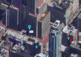
You can easily look from the street view and see what providers are literally in your building like you are walking down the street and looking at the fiber.

To start do a search to where you want to view Internet Providers. Once the results are in select the yellow "pegman" from the map UI controls and drag him onto the street. You may have seen him before but not known what he was used for.


On your search results the streets will light up blue when you are dragging the pegman. Also an info window will pop open showing a view of the street and the pegmans orientation. Let go to drop him and begin street view. It doesn't need to be exactly where you are looking because you can move him around effectively.

 
Our first view looks to be like a garage of some kind. Let's move around to the front of the building. Follow the google arrows to and hold down right click to move your head around to orient yourself. Click on arrows to move forward and screens that follow the walls.

 
As we move we can see the markers changing size and can visually see these carriers are actually inside this building. Hovering over them shows who they are!

 
Coming soon we will be able to see the polyline in the ground and Virtual Reality with Street view will most likely be available by our API so you could virtually look around and see the fiber in the ground! This is way to cool!

Tuesday, June 14, 2016

FirstLight Networks OnNet Buildings Added.


Over 14,000 On Net buildings added to our results for FirstLight Networks, Major fiber provider on the East Coast.


In the above picture you can see FirstLight in the midst of TWC in Maine.

Monday, June 6, 2016

Fiber maps added to Building Lit (buildinglit.com)

 
BuildingLit (buildinglit.com) has made some phenomenal strides in the last month. We have added fiber maps nationwide and you can literally see down to the most finite detail!
 
 
XO Communications in San Jose data centers lit up with descriptions of which data center.

 
Looking closer.. shows underground. Manhole access with multiple fiber strands in the road.
 
Zooming out your can see more of the fiber map.
 
Zooming all the way out you can see fiber path for entire nation.
 
Using toggle switch for fiber you can switch to different carriers we have added.

 
Switching to Integra we can see their west coast foot print.

 
Interesting even shows under water fiber up west coast.

 
We did not realize Wilcon was so densely populated through SoCal and Los Angeles until mapping their fiber.
 
 
Nice honeycomb of fiber for Light Tower in NYC and Manhattan area. Info window on click shows details information on strands available.
 

Fiber tech is also fairly densely populated on East Coast.


 These maps can be used to better understand geographic redundancy for fiber connectivity, route diversity and data center planning. For assistance with a fiber expert please reach out to us at info@buildinglit.com


Wednesday, May 4, 2016

Sattelite View Media Screens and more Real Estate

It was brought to our attention several times that there were a couple improvements we could make regarding the way space was being taken care of on Building lit - Buildinglit.com. So we recently implemented some major improvements.

Now there is just more space on the page we took out the second toolbar that was getting in the way so all devices mobile and lower resolution have more screen to view our map.

Also we were told the satellite view was more professional looking. Take a look at the below image on start up.

We noticed some very cool effects from this.

When you first look for a location you get a top down view of your search: See Empire State Building Search Below.

 However if you zoom in even further. You get a real feel for what carriers and fiber are in your specific area because the camera rotates to a 45 degree angle for you to analyze better.


And you can rotate this as well too.

Huge UI improvement with MouseOver


There have been several huge improvements added to Building Lit - Buildinglit.com in the past couple of weeks. The most notable is a huge improvement in the way the UI works.

Previously you had to rely on the zoom and toggle Pane to select the marker / carrier of your choice.

The reason for this was that some carriers had the exact same latitude and longitude and the markers would land directly on top of each other. To overcome this we had implemented a master image where the markers were in different locations. This worked you could see the different markers, however it bugged up the program in another way. The problem was some markers depending on which one landed first you could not select even though you could see them. The only way to select them was to toggle off the one getting in its way on top of it because there was transparent image data getting in the way of the one below it.

To overcome this we found a way to randomly nudge the markers left right up and down using random PHP math and adding it to the latitude and longitude data for each time. The result is none of the markers are directly on top of each other. This being the case we could instead of using a master image file use a dedicated image with the specific width and height of each marker. This allowed us to also incorporate animations so when you mouse over the markers now you know with precision exactly which one you have highlighted. As you can see in the image above the TWC marker around Disneyland is larger than the other ones because it is being hovered over. Happy hunting for carriers! This is a milestone for us because it was the last main hurdle in the UI and now the program works how it was originally envisioned!

Monday, April 18, 2016

Verizon CA now in carrier list look for more soon.

Posted the release of Building Lit - Buildinglit.com going up for public beta today at http://mangolassi.it/ a great IT site for best practices IT. It was interesting. Those guys being the best of the best asked pertinent questions and gave great feedback. As well as some flaming but that is to be expected with online forums, for the most part though it was very positive. We fixed several bugs and have some things for the roadmap.

One thing that was mentioned was to get Verizon up here on our site. We wanted to let everyone know that we are definitely trying to get more areas and carriers. Right now the main focus has been the main carriers in the main metro areas. Also not all carriers have agreed to participate as of yet. The good news is we were able to add On Net Verizon buildings in California today. We are looking to get the rest of the nation shortly as well to be made available.

As you can see Verizon is up and running. We will be adding some toggle highlights soon as well so you know what you have toggled.

Thanks for all your help guys!

Sunday, April 17, 2016

Local Lec around Empire State Building is TWC Buildinglit.com sattelite view is beautiful, thousands of carriers on Manhattan

So after building Buildinglit.com with Google Maps API V3 we knew there was a sattelite view, but we didn't really mess with it all that much in the construction process and testing of the site. It was just a nice feature there. After doing some recent test searches and completing most of the site I figured I would give it a try. The results really make you even more in tune with what Internet is available and what the lay of the land is.

I found it pretty interesting that it looks like TWC has most of the rights from our data to the Empire State Building. You can see their turquoise marker sits square in the middle of the building. XO and many others are near by so I am sure they don't have any problems delivering services as a CLEC.

Take a look below at these stunning images. Also we find it interesting to note that there are literally thousands of carriers packed into that little sliver of land called Manhattan between the Hudson and East River.


Pretty impressive results from a forward facing tool for commercial use that is free!

Saturday, April 16, 2016

New building from the ground up.. how do I get connected? Single phone line order.


One of our clients recently came to us. They are building a new building. Their construction company asked them where they wanted to put the MPOE for their services once the building was built.  We were able to quickly and easily take a look at what carriers were ON Net and Lit nearby with our buildinglit.com tools for fiber look up. We could see this was ATT and TWC territory so either would do. We then instructed them on the process for getting the kick engineering kick off with the carrier. Surprisingly enough all you  have to do is order a single phone line with them and that will begin the discussion of where to put the MPOE in your new building!

We are now online!


The technology is here we built it. It was much needed! How many times have you been in need of knowing if your building or where you are moving to has fiber hooked up to it, who is the local lec etc.. Well look no further! We have the technology now to do 70% of the research on our own.